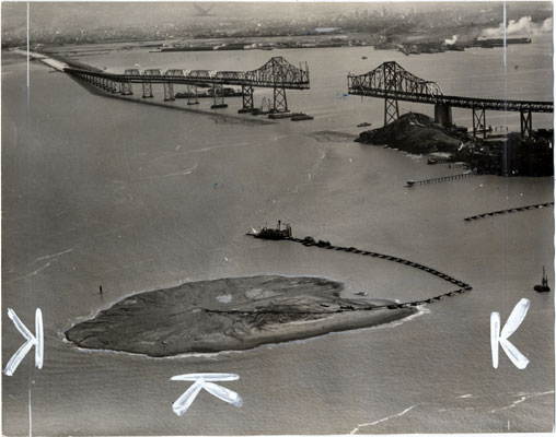
Treasure Island under construction before the completion of the Bay Bridge, 1936. (Clyde H. Sunderland Commercial and Aerial Photographs, from the San Francisco Public Library Historic Photograph Collection.)
As unfolding revelations of fraud and the recent discovery of a highly radioactive object at the former Hunters Point Naval Shipyard garner increasing news coverage and public attention, the situation on Treasure Island remains, for the most part, out of the spotlight—despite concerns about toxicity and resident safety that closely mirror those surfacing at the shipyard. Many island residents live directly adjacent to nuclear waste disposal areas, but they fear the potential repercussions of speaking out about their living conditions in the midst of the housing crisis.
The Anti-Eviction Mapping Project is collaborating with Civic Data Solidarity to map the connections between institutional, financial, and political stakeholders involved in the ongoing remediation and redevelopment plans on the Graph Commons platform developed by artist Burak Arikan. In the next month, we will present the framework for this map here, alongside writings and stories about the intertwined histories of Treasure Island and the Hunters Point shipyard.
We hope the resulting visualization can function as a tool for further investigation, research and storytelling.
The Anti-Eviction Mapping Project is a collective that utilizes data visualization, mapping, and storytelling to center the voices of those facing displacement in the Bay Area. Jin Zhu is an artist and visual storyteller working within the collective.